The Great Dividing Range stretches for more than three and a half thousand kilometres along the eastern side of Australia. The nation’s highest peaks are found in the Australian Alps section of the range, including the record holder, Mount Kosciuszko, at a measly 2,228 metres. They were once much higher, but 300 million years of erosion has worn them down.
Yet here we are, in a cave buried in the side of a mountain with intricate straws and thick stalactite and stalagmite pillars between ceiling and floor, made of the calcium carbonate from the shells of dead sea creatures. How can this be?

These mountains of limestone were once a sea floor. The mighty collisions of tectonic plates thrust the land upwards, folding it into the mountains we are exploring today.
Gundagai lies to the west of the range. Our destination Jindabyne is in the east. There are a few paths to get there. The one we are not doing is the Alpine Way from Khancoban. That was one of the most terrifying drives we have done. Steep, narrow, curvy, a fight with oncoming traffic. Once was enough.
We will go via Tumut. I drive us a little further south via Tumbalong rather than via Gocup, a path we have taken before. From the Hume Highway, Tumbalong is just a historic road side pub, always bypassed. There is actually a township further in, a pleasant rural area of rolling hills, farms, grasslands and willows.
I turn into the Adelong Old Stamping Mill, a little display of the remnants of gold crushing machinery once used in the mines here. I wanted to go through Adelong for no good reason, just remembering the Adelong Electronics shop in York Street opposite the Queen Victoria Building in Sydney’s CBD that I once used to visit. We just drive through the township, continue to Tumut.

When we head over the crest of a hill there is a brief, but spectacular, view of the valley. Smoke rises from a tall chimney, the Visy kraft paper factory.
As we enter Tumut the first order is to find a petrol station. Our quarter tank will not make the full distance to Jindabyne. Opposite the Ampol is the old Tumut railway station.

The railway reached Tumut a hundred and one years ago, the station opening on October 12 1903. It ran from Cootamundra, through Gundagai, terminating at Tumut, with a branch at Gilmour to Batlow and Kunama. Sadly, it closed forty years ago due to flooding without me ever having had a chance to ride on what would have been a very scenic railway.

The heritage listed Tumut station is well preserved and has historical signage. A feature of Tumut was the foot warmer heating plant. These were steel containers filled with crystalline hydrated sodium acetate, then sealed and boiled for 1.25 hours to melt the crystals into a liquid. The containers were placed on the floor of each compartment, providing 10 to 12 hours of heating, or a couple of hours more if turned after 7 to 8 hours. The solidification process releases heat. The process could be repeated by boiling the warmers again at plants like the one in Tumut.

A little further on from the station is the Tumut Visitors Centre, where a glass tank filled with soil and moss, holds a number of black and yellow corroboree frogs. I couldn’t spot any.
We stop at the Woolworths supermarket to buy supplies for the night’s dinner, mistakenly believing that prices would be cheaper than at Jindabyne (they are standard across the chain).
After leaving Tumut the road rises into the mountains, following the eastern side of Bowering Dam. The Snowy River Hydro Scheme was a massive project in the 1950’s to build a series of dams and hydroelectric plants to supply power and water to a developing nation.
The hills on the western side of the dam are denuded and still blackened by the 2019-2020 bushfires that devastated much of the area. There is regrowth, but the fires were so fierce that fire-hardy species that otherwise might have survived did not.
We remember being trapped for the night in Gundagai that summer by the fires, black ash and mud briefly raining from the sky. The last trip before the pandemic.
I can’t admire the scenery, for the road is steep and winding and all my attention is focused ahead.
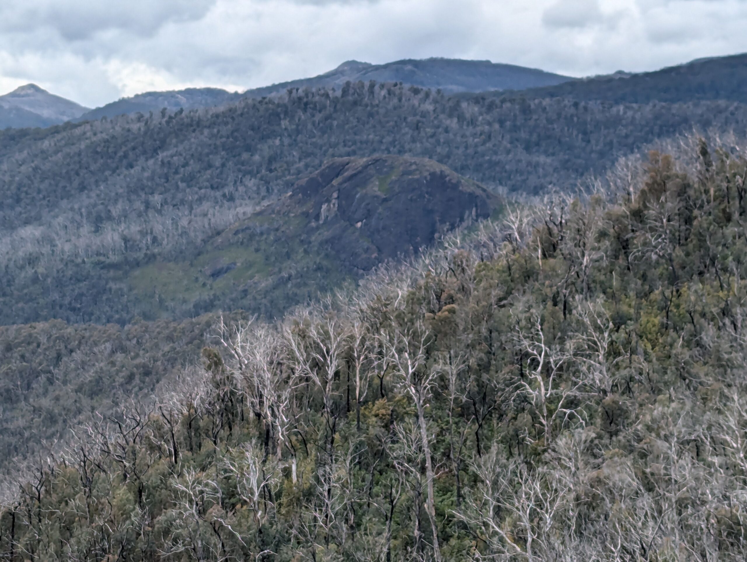
After the particularly steep Jounama Rise, the Snowy Mountains Highway turns away from the dams and the views change to the Bogong Peaks wilderness to the east. I pull over at the Black Perry lookout for a chance to take a look for myself.
There are magnificent views across the eastern ranges. Black Perry is named for a dark rocky outcrop of skarn, where molten volcanic rock almost 600 degrees in temperature came into contact with the limestone and cooked it, creating rare minerals in the process.

The Earth’s inner heat will play a role in our next stop. We turn off at Yarrangobilly. At first the one-way road is sealed, but then we descend into the valley along a narrow gravel track, the navigation system complaining about our detour. Eventually, we emerge into the paved area around the visitor’s centre, which is busy with cars. Parking lower down, we walk up the hill and back to the centre. There we pay the National Park entrance fee of $4 and snag the last positions on the Jillabenan Cave tour.

There is enough time for us to visit another of the park’s attractions, the thermal pool. Driving again around a gravel track, the car park is a steep walk down to the pool besides the Yarrangobilly River.
Rectangular in shape and equipped with change rooms and rudimentary toilets, the pool is a crowded with swimmers and onlooker. The water emerges from deep in the ground at a temperature of approximately 26 degrees centigrade. On a cool day like this it is pleasantly, though not particularly warm. I am the only one out of the three of us who dares swim in it.

The pool is deep and my feet don’t touch the bottom, which is probably a good thing as there is a bit of green algae around. When I emerge, my swimming trunks have a few strands of green on them, much like the algae I extracted from our fish tank the other day, itself kept at a similar temperature.

I think I prefer the warmer (and cleaner) Japanese onsens, but their geology is a bit hot and more active than Australia’s. Still, my body feels really nice after the immersion. I do miss having a bath at home.
It’s lunch time, but the pie warmer at the visitor’s centre was empty and the only food we have brought down with us are one ham and cheese croissant and some cheese and crackers. The other two eat while I swim.
The climb back up to the car is terribly steep and I am glad that my daily exercise routine has included similar walks.
It is another steep gravel road drive up to the Jillabenan Cave parking area, where we meet our guide Josh and sixteen other visitors.
Josh gives an amusing and informative commentary as we walk along the top of the Mill Creek valley to the cave’s entrance. His interests lie more in biology and birds than geology, but he is not familiar with the “stromatolites” that the kids in the party say as the answer to everything (stromatolites are bacterial mats whose presence can be seen dating back over a billion years ago and persist until today).

Jillabenan’s entrance is in the side of the hill, high above the valley floor. It was discovered by a young boy as a small hole in the ground, later dug out to provide a larger entrance for visitors.

Jillabenan is a relative small cave, but there are some lovely formations inside. Many delicate straws and shawls, carrots and stalactites and stalagmites, made of calcium carbonate dissolved from the limestone above, coloured by iron. There is also the black of bushfire ash, “breathed” in by the cave and providing Australia’s longest geological record of fires.

Josh tells us the story of Brian O’Brien, who managed to knock down his carbide lamp with his removed trousers (he was trying to hook them) and end up lost in the dark for 72 hours. He later went on to become a lunar geologist and NASA physicist.
Yarrangobilly is well worth the detour, but now we must make our way to Jindabyne before the camp check-in closes. We drive up the steep gravel track and back to the Snowy Mountains Highway.
The road continues through the mountain bush, but the landscape is changing. The black and the green of the bush changes to the bare grey wood and grasslands of the alpine landscape. This is near empty land, small stone snow huts and clear creeks, of brumbies and spring wildflowers. It is lonely, stark and so very beautiful to my eyes. I regret not stopping to take a closer look.
Snow can still be seen high in the far ranges, this being a poor season. The sky is mostly blue, but some of the cloud by the peak may still harbour flakes of snow.
We turn off the Snowy Mountains Highway at Middlingbank Road and take a direct route to Berridale, a pretty town lined with poplars. From there it is a more familiar ride along Kosciuszko Road into Jindabyne, weaving above the man made lake and across the dam wall into town.

Our cabin here is small, with not enough power points and too-soft beds, but otherwise comfortable. I am so tired from the drive and hungry from a lack of lunch that I could collapse, but B insists on buying more groceries and cooking in the cabin.
I eat, shower, and collapse early into bed, exhausted from the adventures of the day, but satisfied that it was been a great adventure.